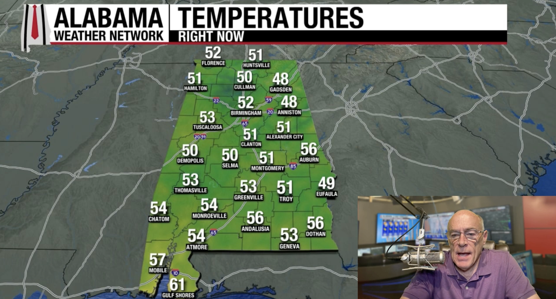


Mornin' folks! Feeling that crisp air? Some spots in Alabama are rockin' the 40s this AM, but most of us are chillin' in the 50s. Get ready for a serious warm-up though! Sunny skies mean we're headin' for the low to mid 80s this afternoon. And guess what? This dry, delightful weather is stickin' around all week! Highs in the 80s, lows mostly in the 50s. Ahhh, perfect! Hold onto your hats, ChumCity! Moisture's movin' in Saturday, but most of us should stay dry with temps hangin' around 80. Keep an eye out for a few isolated showers in the southwest corner of the state Saturday afternoon. Then, BOOM! Saturday night and Sunday, expect showers and thunderstorms statewide ahead of a cold front. We're talkin' about half an inch of rain for most, maybe an inch in a few spots. Won't end the drought, but it's a start, right? And after the rain? Cooler, drier air swoops in! Looks like smooth sailin' weather-wise for the first half of next week. But word on the street (from the global models, that is) is we might see another chance of rain by Friday, October 24th. Tropical Storm Lorenzo's churnin' in the Atlantic, way out there about 1090 miles west of the Cabo Verde Islands. Winds are at 45 mph, movin' northwest at 17 mph. Looks like it'll stay below hurricane strength and veer north into the open ocean. No worries for us! The rest of the Atlantic's chillin' – no tropical storms or hurricanes expected in the Gulf for at least the next 7-10 days. Phew! Hurricane Hazel tore through the Bahamas with 100 mph winds! It strengthened even more, making landfall on the North Carolina/South Carolina border as a Category 4 hurricane. Whoa! An early season lake effect snowstorm buried Buffalo, New York! Downtown got a whopping 15 inches, while Depew and Alden saw a crazy 24 inches! Talk about an October surprise!Sweet Sippin' Weather, Chumsters!
Weekend Forecast: Rain is a' Comin'!
Tropical Tidbits:
Weather History Flashback!
October 15, 1954:
October 15, 2006: